Antique Hand-Colored Map of Italy, Sicily and Malta, 1860
You are now following Charts. You can manage alerts in your account settings.
You have unfollowed Charts.
Unfortunately, this action has failed. Please refresh the page and try again.
You have added this product to your wishlist.
You have removed this product from your wishlist.
Unfortunately, this action has failed. Please refresh the page and try again.
You can view your wishlist here.
Antique Hand-Colored Map of Italy, Sicily and Malta, 1860
Antique Hand-Colored Political Map of Italy, 1860
Antique Map of North Circumpolar Regions with Kamtschatka and Vancouver Island, 1860
Antique Hand-Colored Map of Greece and Ionian Islands, 1860
Antique Hand-Colored Map of Turkey in Europe and the Balkans, 1860s
Antique Map of Middle Eastern Region, 1860
Albin, Butterfly Life Cycle on Oak & Wallflower, 1720, Paper
Enlightenment Map by Rigobert Bonne, 1780
Venezuela, New Granada and Ecuador, Antique Map, Northern South America, 1860
Antique Map of the Arabian Peninsula, 1860
Denmark with Schleswig & Holstein, Iceland, Greenland, Antique Map, Blackie 1860
The Caribbean & Gulf of Mexico Rigobert Bonnes Antilles Map, c.1780
Antique Map of Indo-China, 1780s
Antique Map in Paper, 1860
French Guiana and Suriname Colonial Map of the Guianas by Rigobert Bonne, 1780
Northern Europe and Arctic Regions Map by Rigobert Bonne, 1780
Antique Map of South and Southeast Asia, 1860
Antique Map of Central America and Gulf of Mexico, 1860
Antique France at the Age of Enlightenment Map by Rigobert Bonne, 1780
Isthmus of Caucasus and Armenia Map, 1860
Antique Biblical Map of the Holy Land, 1650
The Netherlands Seven United Provinces Map by Bonne, 1780
Antique East Asia Map by Bonne, 1780
British Isles England and Scotland and Ireland Map by Bonne, 1780
Belgium Foederatum Map by Seutter, 1700s
Antique Map of the Middle East and Georgia by Rigobert Bonne, 1780
Antique African Sea Chart, 1780
Antique Map of Arabia by Rigobert Bonne, 1780
Antique East Indies Map by Rigobert Bonne, 1780
Antique Greek Map of Aegean Sea and Crete, 1697
Antique Hand-Colored Map of Ancient Gaul, 1748
Antique Dutch East Indies Sea Chart, 1700
Antique Cotton Botanical Print, 1831
Map of Duchy of Brunswick-Lüneburg, 1595
Antique Miniature Map of Ireland by Du Val, 1679
Baroque Solar System and Zodiac Map, 1742
Antique Chestnut Castanea Vesca Botanical Print, 1831
Antique Birds-Eye View of Hangzhou by Matthäus Merian, 1638
Antique Holy Land Map, 1700
Twelve Tribes of Israel Samson Map
Antique Asian Map with Guam Inset, 1700
Ottoman Empire Map by Jean Chiquet, Paris, France, 1719
Antique Map of Celebes Sulawesi, 1754
Antique Map of Europe and the Mediterranean, 1748
Peru and Bolivia City Plan, 1750, Paper
Duke of Berwick Campaigns Map, 1707
French Naval Sea Chart with Mozambique Bay by Bellin, 1765
Monomotapa Empire Map, 1740
Egypt and Abyssinia with Nile Valley and Horn of Africa Maps, 1817
Egypt Nile Valley Map by Danville, 1765
Historical Map of Northern Europe and Russia, 1788
Syene and Elephantine Island Egypt Engraving, 1755, Paper
French Map of Cape of Good, Hope Fort and City Plan, 1765
Loudun and Mirebeau Map by Blaeu
Map of North America, 1700
Antique Map of Scandinavia by Van Der Aa, 1710
Large Hand-Coloured Map of Rhine River, Moselle and Meuse by Willem Blaeu, 1640
Normandy Map by Frederick De Wit, 1705
Map of Palestine by Frederic De Wit, 1670
East African Coast Map by Bellin, 1740
Antique Map of the Frankfurt Region by Johannes Janssonius, 1650
Copper Engraved Map of France
Cartographic Depiction of Flensburg and Surrounding Territories, 1648
Map of the Margraviate and Electorate of Brandenburg by De Beaurain, 1750
Antique Tobacco Nicotiana Tabacum Botanical Print, 1831
Antique Sago Palm Botanical Print, 1831
Antique Kingdom of Ireland Map from De Vaugondy, Venice, Italy, 1778
Antique Map of the Peloponnese Peloponnesus by Cluver, 1697
Comoros French Naval Sea Chart with Anjouan Island by Bellin, 1765
West Africa French Exploration Map with River Sanaga, 1750s
Nubia and Abyssinia Venetian Map of Northeast Africa from Zatta, 1784
Antique Engraved Map of Manche with Mont Saint-Michel in France, 1850
Antique Decorative County Map of Lincolnshire, 1804
Ancient World Map After Strabo by Cellarius, 1731
Map of Papua New Guinea and the Salomon Islands, 1600
Hand-Colored Engraved View of Rhodes and Island of Rhodus by O. Dapper, 1687
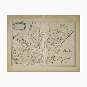
Map of Scotland Etching by Johannes Blaeu, 1650s
Egypt and Arabia Petraea Nile Map, 1815
North & South Africa Double Map, 1825
Map of India and Ceylon with Inset of Calcutta and the Ganges by Bonne, 1780
AntiqueMap of the City of Deventer, 1588
Map of the Mariana Islands by F. Bernard
Map of Saint Helena Island by F. Bernard
Antique Map of Palencia Province, 1901
Map of Malaysia and Singapore, 1600
Map of the Margraviate of Brandenburg by Giacomo Cantelli Da Vignola, 1687
Map of Persia, 1730
Antique Map of the Burmese Empire and Upper Indochina By Dalrymple, 1800
Historical Map of Holstein by Matthias Seutter, 1730
Antique Hand-Coloured Engraved Map of French Coastal Town Cherbourg, 1666
Large Sea Chart of the Zuyder Zee and the Northsea with the Wadden Islands, 1773
Map of Blaisois by Janssonius, 1633
Antique Map of the County of Burgundy by Johann Baptist Homann, 1710
Antique Map of French Heritage, 1600s
Antique County Map of Durham, England, 1804
Antique County Map of Monmouthshire, England, 1804
Trending